Letter A
1. Abū ‘Ayāt / Abū ‘Ayāteh | أبو عياط
al-Mafraq Governorate
Maqām / Weli Abū ‘Ayāt with masjid
JADIS no. 2419010
MEGA no. 7251
Coordinates: 32° 20’ 43” N, 35° 59’ 06” E
32.345278, 35.985000
Letter A
al-Mafraq Governorate
Maqām / Weli Abū ‘Ayāt with masjid
JADIS no. 2419010
MEGA no. 7251
Coordinates: 32° 20’ 43” N, 35° 59’ 06” E
32.345278, 35.985000
Plan: unknown.
Measurements: unknown.
Exterior: unknown.
Interior: unknown.
Building Materials: yellowish-brown local limestone.
Construction details: The NE corner was probably chiseled out of the virgin rock, below this corner appears the opening of a natural cave (figs. 1.5-6); in the E vicinity traces of ancient quarrying activities (fig. 1.7).
Preservation: Few remains of a church on the top of the Tell (fig. 1.2) had been reported by Muheisin and Turshan in 1991. The Islamic mausoleum is entirely destroyed by bulldozing and illicit digging. The location of the maqām is still surrounded by several old terebinth (buṭm) trees (fig. 1.1).
Inscription(s): To the N of the sanctuary extends an old cemetery, the area to the NW is still in use for burials. One of the old graves has a headstone on the W end on which faint traces of an incised cursive Kufi script are visible. It might be possible that this is a reused boulder of the Islamic mausoleum:


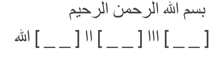
Translation: “In the name of Allāh, the Merciful, the Compassionate (bismillāh) [....] Allāh [. ]” (reading
and facsimile copy by HAJ and MF 2020). Date(s): Probably Pre-Ottoman.
Traveler Reports: “Am Nordende von Sa’d erhebt sich der weli abû ‘ajât mit einer Gruppe alter Terebinthen.“ (Schumacher 1901); “Nordwestlich unterhalb des Tell liegt das weli abū ‘ajât (998 m) mit einer Gruppe schöner, uralter butm, die von der Hand der Zerstörer noch nicht angegriffen sind... Bei dem Weli finden sich ferner die Ruinen eines arabischen Gebäudes, wohl einer dschâmi‘...” (Steuernagel 1927).
Bibliography: Schumacher 1901, 5; Steuernagel 1927, A. 135. 368;
Muheisen - Turshan 1991, 18-19.
 Fig. 1.1 General view of the site of the maqām surrounded by terebinth trees, in the foreground left cemetery, in the background Tell, from W (TMW-K 2020).


