Letter F
112a. Fedayn, al- | الفدين
al-Mafraq Governorate
Ḥājj fort, Qal’a
JADIS no. none
MEGA no. 58455, 58436
Coordinates: 32°20'43.5"N 36°12'05.0"E
32.345422, 36.201389
Letter F
al-Mafraq Governorate
Ḥājj fort, Qal’a
JADIS no. none
MEGA no. 58455, 58436
Coordinates: 32°20'43.5"N 36°12'05.0"E
32.345422, 36.201389
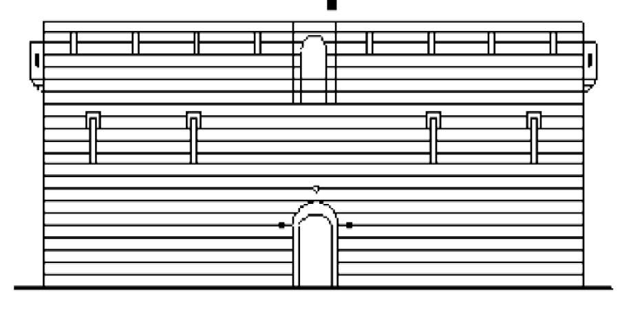
Plan: Square plan with gate in the N. The entrance to the fort was an arched opening... Above this, at first floor level, there was a projecting box machicolation (fig. 112a.8). Apart from the area around the entrance, there were no decorative features on the exterior of the fort, though a number of arrow slits/gun ports can be seen at first floor level. The entrance led, via a vaulted iwan, into a small central courtyard with a series of rooms at ground floor level. On the upper level (first floor) no rooms are indicated, the only visible features being niches for the gun ports/ arrow slits (Petersen 2012).
Measurements: unknown.
Exterior: 19.22 x 19.15 m (Rjoub - Housan 2010).
Interior: unknown.
Building Material: limestone with a considerable portion of reused basalt blocks.
Construction Details: two sided masonry of predominantly brownish to white limestone blocks with the occasional intrusion of basalt ashlars. The exterior and interior walls were constructed in horizontal rows up to 21 courses high. The cores of the walls were filled with rubble and earth. The courtyard is paved with white limestone and black basalt slabs in irregular arrangement (authentic or recent reconstruction? (fig. 112a.11).
Inscription(s): Directly above the arch of the doorway there was a small rectangular recessed panel, probably containing an inscription. Nothing of the content of this inscription is known.
Date(s): The fortress was built soon after the Ottoman conquest of Syria in 1516 by order of Sultan Selim I. together with a number of other fortified pilgrim stations along the northern Ḥājj route. The al-Mafraq fort is first
mentioned 971 H / 1563 AD) in the itinerary of Mustafa Pasha.
Conservation: Ruined and conserved, today located within the antiquities site of the local DoA branch to the NE of the Umayyad house with the mosque (no. 112). The fortress was abandoned already in the 19th century if not earlier. It has been demolished in 1957 by the Iraqi army to make space for the Trans-Arabian petrol pipeline from Baghdad to Haifa. Fortunately some black and white photographs taken by the DoA prior to the dismantling survived in the archives of the Rockefeller Museum in Jerusalem (Petersen 2012, pls. 17-20 = here figs. 112a. 4-7).
Traveler Reports: The first description of the fort is given by Evliya Çelebi who visited it in 1672 … He states that it was a square fort, built in the middle of the desert, by the Bani Hillal. However, at the time of his visit there was no garrison inside, it being occupied by Bedouins who used it as a place to keep sheep and goats. Outside there was a green meadow with large acacia trees and plentiful water. In 1709 the pilgrim Murtada ibn 'Alawan stopped at Mafraq where the pilgrims erected their tents.... Seventy years later, Mafraq was visited by Mehmed Edib, who noted that it was a dangerous place because of flash floods. According to Edib the name is derived from the fact that, here the returning pilgrims broke free from the caravan and raced back to Damascus …
Burckhardt was the first European traveler to mention Mafraq, describing it as ‘a castle four hours from Ramtha, where the Pasha keeps a small garrison, under the orders of the Aga, or Obadashi.’ Burckhardt notes that the Bedouin of the area use the fort as a storehouse for grain, which they either sell to pilgrims, or keep for the following year .... Elsewhere he describes Mafraq as ‘a ruined castle situated on the eastern extremity of Djebel Zouueit.’ When Doughty followed the Hajj caravan from Damascus in 1875 he passed the fort at Mafraq, describing it as ruinous and abandoned...” (Petersen 2012)
Bibliography: Rjoub – Housan 2010, 45-68; Petersen 2012, 57-59 plates 17-20