Letter H
137.Ḥōfa al-Wusṭīyah / Ḥawfa| حوفا الوسطيّة
Irbid Governorate
Maqām / Wēli Shēkh Sa’īd Sāleḥ
JADIS no. 2121092
MEGA no. 10587, maqām: 47028.
Coordinates: 32°34'12.5"N 35°42'51.0"E
32.570139, 35.714167
Letter H
Irbid Governorate
Maqām / Wēli Shēkh Sa’īd Sāleḥ
JADIS no. 2121092
MEGA no. 10587, maqām: 47028.
Coordinates: 32°34'12.5"N 35°42'51.0"E
32.570139, 35.714167
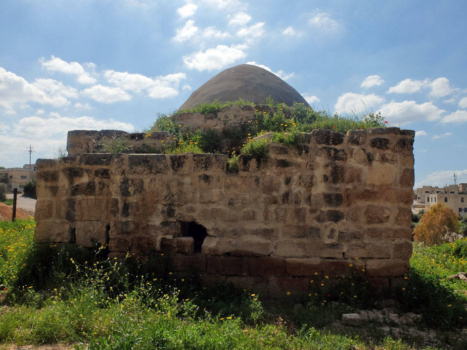
Plan: almost square, with entrance from the N wall. The plan in the interior is not symmetric due to the reuse of an older building and at least three phases of subsequent constructional changes. The dome rests on the four corner buttresses supporting arches on all sides with pendantifs. The E and S arches are deeper due to alterations in former construction phases.
Measurements: 17.76 m2
Exterior: 15 x 24.5 cm (Abu Dalu); 6.8 x 6.7 m (GJU survey).
Interior: 13.5 x 20 m (Abu Dalu); 3.7 x 4.8 m (GJU survey).
Building Materials: brown limestone of local origin, the blocks are fairly well dressed and probably from an older date (reused).
Construction details: The masonry is executed in the customary two sided technique with loose stone rubble and earth fill between the exterior and the interior walls. The blocks on both the exterior and the interior sides are laid in horizontal layers with considerable care. The dome rests in the interior upon pointed arches set in square along the walls, in the groins between them the pendantifs are clanged. The interior NE wall sector is considerably thicker than the other interior walls of the building. Possibly this sector contained the tomb of the Shēkh. In the lower zone of this interior wall section is a niche with rounded upper frame, the keystone is emphasized by reddish color. At the S end, the building had been reinforced by a thick retaining wall, possibly with a miḥrāb niche incorporated into the wall to mark the qibla.
Preservation: Ruined and not in use for Muslim prayer. The NW corner with a large portion of the N elevation has been rebuilt in recent times. The S wall, restored by Abu Dalu in 1994, has been destroyed again in recent time by treasure hunters. Also the interior of the building has been vandalized by looting. The imposts of the dome are partly in fragile condition.
Inscription(s): none known.
Date(s): According to pottery evidence, the site has a continuous occupation during Umayyad, Abbasid and Mamluk times (Daire 1988). The maqām in its present condition raises upon an older artificial terrace, the retaining walls of which can be clearly seen at the NE corner and the sloping terrain of the steep W slope. The retaining walls consist of big limestone blocks set in horizontal courses without mortar. According to the dome construction, a date in the earlier or middle Ottoman period seems probable. Large portions of the N-façade must have been rebuilt in the mid of the 20th century AD including the upper part of the central dome cast in concrete.
Traveler Reports: “The Weli in the east is that of the Mohammedan Sheikh Sa’id” (Schumacher 1890 [reprint 2010]); “Die Eingänge zum Gehöft des Schêch zeigen sorgfältig gearbeitete steinerne Türstürze mit modernen Ornamenten und Koraninschriften. Das im Osten gelegene Weli gehört dem Schêch Sa‘id.” (Steuernagel 1927,457-458).
Bibliography: Schumacher 1890 (reprint 2010) 135; Steuernagel 1927, A. 457-458; Daire 1988, 74 s.v. Hōfa (el-Wistiyah); Abu Dalu 1994, 5-19 fig. 2; Rawadiyah 2007, I, 441; Stilkacheva 2018, 387 s.v. Hūfā.