Letter S
344. Semmū’ / Kanūsī Khirbet al- /Khirbet Mesḥhādi / Rakhm | سمّوع
Irbid Governorate
Maqām Shēkh Muḥammad al-Qanūsī
JADIS no. none
MEGA no. 3182
Coordinates: 32°31'11.0"N 35°43'25.7"E
32.519722, 35.723806
Letter S
Irbid Governorate
Maqām Shēkh Muḥammad al-Qanūsī
JADIS no. none
MEGA no. 3182
Coordinates: 32°31'11.0"N 35°43'25.7"E
32.519722, 35.723806
Plan: square or rectangular.
Measurements: unknown.
Exterior: unknown.
Interior: unknown.
Building Materials: local limestone with older spolia.
Construction details: Apart from the reference on the dome by G. Schumacher (Steuernagel 1927), nothing else is known on the construction.
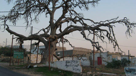
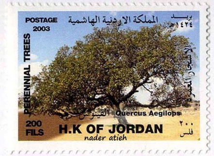
Preservation: Only the old oak tree (quercus aegilops) survived until several ago (cf. figs. 341.2-3). Due to the inconvenient environmental factors the tree died and was removed. Today nothing remains of the maqām.
Inscription(s): none known.
Date: unknown, probably Ottoman or Mamluk.
Traveler Reports: “Man erreicht auf ihr zunächst die im Ackerfeld von semmu’ liegende Ruine el-meschhadi. Nahe dabei liegt das Weli des schēch muhammad elkanūsī, ein früherer Kuppelbau aus alten Steinen mit einem Grab und einem mallūl-Baum. Nach ihm wird die im SW auf einem terrassierten Hügel gelegene größere Ruinenstätte mit großen Bausteinen und Grabhöhlen, die nach Auskunft von schêch ‘Alî von semmû’ früher rachm hieß, jetzt gewöhnlich chirbet el-kanûsî genannt” (Steuernagel 1927).
Bibliography: Steuernagel 1927, A. 418; Nueimat - Alkilani 2002, 47.