Letter T
391. Tlāḥ / Telah / Toloha (?) / Samāta | طلاح
al-Kerak governorate
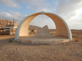
Memorial (ṣarḥ) for Ka‘b ibn ‘Umair al-Ghifāri al- Anṣārī
JADIS no. 1802019.
MEGA no. 8601.
Coordinates: 30°50'36.2"N 35°24'33.9"E
30.843389, 35.409417
Letter T
al-Kerak governorate
Memorial (ṣarḥ) for Ka‘b ibn ‘Umair al-Ghifāri al- Anṣārī
JADIS no. 1802019.
MEGA no. 8601.
Coordinates: 30°50'36.2"N 35°24'33.9"E
30.843389, 35.409417
Plan: newly built (1986).
Measurements: not available.
Exterior: not available.
Interior: not available.
Building Materials: white limestone with concrete.
Construction details: new concrete-stone construction.
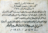
Preservation: The monument is a historical marker placed along the highway. It is not identified as a maqām. The dedicatory inscription from 1986 identifies it as a ṣarḥ to perpetuate the memory of this companion of the Prophet Muḥammad who was martyred 1 km away. There is no suggestion that his grave is here or that anyone has ever come to this exact spot for visitation as a shrine, or that anybody should do so. Further east of the modern highway Ghōr as-Sāfi - al- ‘Aqaba extends an antiquities site (fig. 391.2) with a caravanserai and a water pool. This has been first visited and briefly described by Alois Musil in 1907. The ruins provide no evidence for a Muslim sanctuary related to Ka’b ibn ‘Umair al-Ghifāri al-Anṣārī.
Date(s): Ka’b ibn ‘Umair al-Ghifāri al-Anṣārī was the leader of a military expedition commanded by Prophet Muḥammed against the polytheists of the Banu Quda‘ā at Dhāt al-Aṭlāḥ (“the place of the palm trees”) in H 8 = AD 629. The confrontation ended by a fatal defeat of the Muslim warriors who were killed except one who was able to report the desastrous event to the Prophet. The authenticity and the age of the site is unclear. The present memorial (ṣarḥ) was built in H 1407 = AD 1986. As far known, there was nothing at this spot prior to 1986.
Traveler Reports: none known.
Bibliography: Arabia Petraea II, 209-210, HSJ 69; Hattab 2015, 68- 69; Findlater 2003, 396 fig. 77; Schick 2020, no. 126.


