Letter M
231. Ma‘ān, Wādī Shāmīya | معان، وادي الشامية
Ma‘ān Governorate
Maqām / Weli Umm Jdī’
JADIS no. none
MEGA no. none
Coordinates: 30°12'27.6"N 35°44'38.0"E
30.207658, 35.743889
Letter M
Ma‘ān Governorate
Maqām / Weli Umm Jdī’
JADIS no. none
MEGA no. none
Coordinates: 30°12'27.6"N 35°44'38.0"E
30.207658, 35.743889
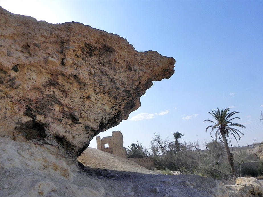
Plan: Mietunnen 2013: “There are ruined walls from older structures, as well as an old garden beside the site. The site itself is part of the eroded riverbed [scil.: of the Wādī Shāmīya in the northern outskirts of the town]. It protrudes from the southern bank of the wadi, curving outwards and forming a small, about three meters high shelter.”
Measurements: unknown.
Exterior: unknown.
Interior: unknown.
Building Materials: unknown.
Construction details: unknown.
Preservation: unknown.
Inscription(s): none known.
Date: Neither the date of the shrine nor the identity of the personality venerated in it are firmly determinable. It obviously relates to a pious women who was known for her works of charity. According to Miettunen’s informants her tomb was on the top of the rock, but nothing survives. According to Jaussen (1908, 302): “people who went under the formation for shelter started seeing the spirit of the rock manifested in their dreams in the form of a snake or a woman and telling them that she was the waliya of the rock. When these incidents continued, the place became a holy site, favored especially by the women of Ma’ān” (Miettunen 2013, 106). The peculiar Arabic name ‘Umm Jdī’ (according to Jaussen 1908: ‘Umm Jedeī’ah) = “Mother of the mutilated” probably refers to the strange rock formation.
Traveler Reports: see above under plan and date.
Bibliography: Jaussen 1908, 302; Miettunen 2013, 106 no. 16; 210 fig. 15; Schick 2020, no. 67.