Letter S
354. Shiḥān, Tell | تل شيحان
al-Kerak Governorate
Maqām Mūsā ibn ‘Imrān
JADIS no.220 8039
MEGA no.11094
Coordinates: 31°22'47.0"N 35°44'13.1"E
31.379719, 35.736961
Letter S
al-Kerak Governorate
Maqām Mūsā ibn ‘Imrān
JADIS no.220 8039
MEGA no.11094
Coordinates: 31°22'47.0"N 35°44'13.1"E
31.379719, 35.736961
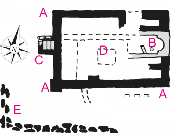
Plan: large monastic compound on top of the hill, fenced by a rectangular wall (width about 1.30 m) of unworked basalt boulders with fill of earth and rubble. In the center of the E sector traces of a Byzantine church, semicircular apse directed to the E. On the opposite W end of the open courtyard a rectangular building with floor covered by careful worked large limestone slabs, probably the venerated tomb; along the S bottom of the hill basalt boulders delimitating the area of a Muslim cemetery.
Measurements: unknown.
Exterior: size of rectangular enclosure ca. 60 x 40 m.
Interior: unknown.
Building Materials: basalt, light brown limestone (for the church and parts of the tomb), light-grey oil-shale as a substitute for marble (in the church).
Construction details: church covered by barrel vaults.
Preservation: According to Islamic tradition Shiḥān is the place where prophet Moses / Mūsā died viewing the “promised land”. Christian tradition has translocated this episode to Jabal Nēbō/Rās al-Ṣiāgha (no. 361). A. Musil mentions the veneration of an eponymous saint called Shiḥān by the tribe of the ‘Agēlāt. Is is not known whether this Saint is associated with Mūsā ibn ‘Imrān, who was venerated at this sanctuary by the southern clans of the Ḥamāyde tribe (loc. cit.).
Inscription(s): none known.
Date: Byzantine to Ayyubid.
Traveler Reports: (Harawī 18, 3): “At Mo’ab is a village called Shīḥān, which contains a tomb upon which light descends and the people see it. It is upon a mountain. It is alleged that it is the tomb of Moses son of Amran. God knows best.” (Meri 2004,38. 38; Sourdel-Thomine 1957, 46-47); “...el-’Agêlât verehren Šihân; er erbaute Šihân und ist dasselbst begraben ... Die südlichen Hamâjde verehren Mûsâ ibn ‘Emrân.” (Arabia Petraea).
Bibliography: Arabia Petraea III, 330; Worschech 1985b, 169-172 fig. 7; Miller 1991, 31-32 site no. 12; Michel 2001, 139; Schick 2020, no. 114.


